 |
 |
 |
IRON AGE / EARLY HISTORIC
PORT-SITES OF THE INDIAN COASTLANDS
Dr. Sunil Gupta
Allahabad Museum,
India
INTRODUCTION
Dr. Sunil Gupta has provided photographs of some of the Early Historic coastal sites explored by him on the western and eastern coasts of India. The term Early Historic broadly spans the period from 5th century BC to 3rd century AD. It covers the main dynastic periods of northern India: Maurya (5th - 2nd century BC), Sunga (1st century BC), Kushan (1st-3rd century AD).
Most of the coastal sites can be identified in the list of ancient ports provided in the Greco-Roman records, principally the Periplus Maris Erythraei (1st century AD), the Natural History of Pliny (1st century AD) and the Geographia of Ptolemy (2nd century AD) book 7.
Bharuch (District Bharuch, Gujarat State)
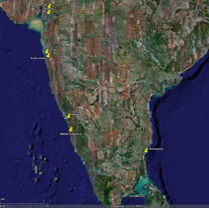
The modern city of Bharuch is situated on the remains of the ancient port of Brghukaccha or Barygaza as it was known to the Greeks. The city is located on the banks of the river Narmada, about 40 kilometres upstream of the Gulf of Khambat. Archaeological deposits are to be found in places within Bharuch city limits. One such mound is located behind the Panchayat Office (Fig. 1). Sections exposed on the mound indicate that the deposit was part of a settlement flourishing during the BC-AD transition. This was the period when Brghukaccha or Barygaza functioned as a great trade port of the Indian Ocean. The Greek sea guide of the 1st century AD, the Periplus Maris Erythraei, refers to Barygaza as the destination of Roman ships departing from harbours on the Red Sea. On the outskirts of the city, pottery of Early Historic period was found scattered on the high alluvium of the river bank at a place called Baba Chaman (Figs. 2, 3, 4). Baba Chaman may have been a berthing station for ships sailing upto Bharuch from the open sea. The Periplus refers to such berthing stations in the deep part of the river Narmada. The river Narmada was observed at the point it meets the Gulf of Khambat (Figs. 5, 6). The Periplus informs of a dynamic marine environment at the mouth of the Narmada, with tides rising as much as 15 metres.
Picture gallery
Kamrej (District Surat, Gujarat State)
Early Historic site on the south bank of the river Tapi in the Gujarat state of India. The main mound near Kamrej village is approximately 300 m x 200 m in area. The archaeological deposits overlie 5 m of alluvial formations. The mound is oblong and gives the impression of a fortified settlement from the river (Fig. 1, 2). Kamrej was excavated by a team from the Indian Archaeological Society in 2003 with the author as co-director of excavations. A three phase stratigraphy within a single cultural period (the Early Historic) was revealed in the main section at Kamrej mound (Figs. 3). The chronology of the three phases is as follows: Phase I (1st-2nd century AD); Phase II (2nd-3rd century AD) and Phase III (3rd-5th century AD). The three phases (1st-5th century AD) were indicated by successive fired brick structures (Fig. 4)
It is posited that the three phases at Kamrej represent quick rebuilding activity in the early centuries AD. The rebuilding must have been oriented to overseas trade as Kamrej has been identified with the port of Kammoni mentioned of the Periplus Maris Erythraei. In all likelihood, the structures at the edge of the Tapi at Kamrej were part of a port installation and probably functioned as loading/unloading platforms and river facing wharves.
Picture gallery
Chaul (District Ratnagiri, Maharashtra State)
The modern township of Chaul is the site of an ancient harbour flourishing in the BC-AD transition. Chaul is situated along the Roha Creek some 40 km south of Mumbai on the Arabian Sea. Chemulaka mentioned in An inscription at the rock cut caves at Kanheri refers to Chemulaka or ancient Chaul. The Greek sea guide, the Periplus Maris Erytharaei and the Geographia of Ptolemy call this port Semylla. Ptolemy records that he obtained much information about western India from merchants from Egypt frequently voyaging to Semylla/Chaul. The Early Historic port of Chaul must have been situated close to the large Roha Creek which cuts into the hilly tracts of the modern Chaul township till it reaches the mouth of the Kundalika River. The modern approach road from Alibag to Chaul crosses a network of deep-water channels which are extensions of the creek itself. The author noticed that these inland sea-channels were effected by the rise and ebb of tides and that many fishing boats were operating there. The importance of this waterway network in Early Historic period can be clearly conceived.
The early Buddhist rock-cut caves on the Hinglaj Mata Hill overlooking Chaul offer a direct view of the open sea at the mouth of the creek (Fig. 1). The Buddhist nature of the caves is indicated by a stupa carved inside a cave (Fig. 2). The remains of an Early Historic berthing station has been located on an old mudflat of the Kundalika river by Professor Vishwas Gogte of the Deccan College, Pune. The old mudflat is about 1.5 m above the present waterline of the Kundalika river. The archaeological remains are indicated by the spread of Early Historic and Medieval Period pottery on a area of 900 x 150 m. Gogte could obtain a stratigraphy of the old harbour by recording the sections exposed in the freshly dug wells in the site area. The sequence shows that the earliest occupation commenced in the 'pre-Satavahana/Mauryan period' dating to the latter half of the 1st millennium BC. The succeeding Satavahana Period, which is synonymous with the period under review (1st century BC - 3rd century AD), is characterized by common red ware utility vessels, fired bricks and saddle querns. A bodysherd of a amphora was also found in the Satavahana levels. Semylla or ancient Chaul was connected with Early Historic settlements in the Deccan uplands through passes in the Western Ghats.
Picture gallery
Kuda (District Ratnagiri, Maharashtra State)
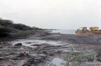
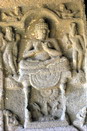
At the head of the Janjira Creek lie the Buddhist rock cut caves at Kuda. The Kuda Caves are carved on a hillock overlooking the village of Mandad on the shore of the Janjira Creek (Figs. 1, 2). The caves were hewn by Buddhist mendicants following the Hinayana creed. The interiors of the caves are carved with stupas in the round (Fig. 3) as well as in pilaster (Fig. 4). Balustrades and verandahs imitate wooden architecture, as can be seen in the stone 'dowells' protruding below a beautifully decorated balustrade (Fig. 5). The Kuda Caves were excavated from the 1st century BC to the 2nd-3rd century AD. Later, with the spread of the Mahayana creed, figures of the Buddha in meditation were carved in the caves during the 6th-7th century AD (Fig. 6).
Kuda was mostly likely the location of the port of Mandagora listed in the Periplus Maris Erythraei and the Geographia of Ptolemy. Pottery of the Early Historic period was recovered by the author near the beach head at Kuda.
Picture gallery
Haigunda (District Uttara Kannada, Karnataka State)
The riverine island of Haigunda is located in the middle of the river Sharavati (Fig. 1) in northern Karnataka. Haigunda island is about 20 kilometres upstream of the Arabian Sea. A further 25 km upstream are the Gersoppa Falls, the highest waterfall in India (253 m). Archaeological deposits of the Early Historic - Historic period (2nd-3rd - 5th century AD) were observed on top of a hillock at Haigunda Island. A statue of a large yaksha (divine figure) was found in a sacred grove on the island. The large yaksha statue (1.69 m high) has been dated to the 4th century AD (Figs. 2, 3). The yaksha images signified strength and protection in ancient times and this larger than life image must have been venerated by sailors and merchants on Haigunda island. Besides the yaksha statue, there is an image of Vishnu flanked by two Buddha images on the outskirts of Haigunda Village (Figs. 4, 5, 6, 7). The Vishnu image can be attributed a date of 5th-6th century AD and the Buddha figures seem to be of a later date, about 8th century AD. Sivalinga carved in stone lie scattered in the fields on Haigunda island. These could be dated between 4th - 8th century AD (Fig. 8).
Picture gallery
The author has identified Haigunda island with the port of Naura mentioned in the Periplus Maris Erythraei.
Malpe-Udyavara (District Dakshin Kannada, Karnataka State)
The sites of Malpe and Udyavara are situated on the southern part of the Kanara Coast. Malpe is mentioned in a Greek farce written in the 2nd century AD and contained in the Papyrus Oxyrhynchus. The Greek play narrates the tale of a Greek lady who was abducted by the 'Malpiniak' or Chief of Malpe till she was rescued by Greek sailors. Malpe is a modern harbour today at the mouth of a creek (Fig. 1). Udyavara is situated at the head of the creek. There are disturbed archaeological remains (pottery, laterite blocks) about 100 metres from the head of the creek. A temple to Shiva on a hill near Udyavara revealed a sanctum sanctorum of the Early Historic period (Fig. 2).
Picture gallery
Arikamedu (Union Territory of Pondicherry)
The Early Historic site of Arikamedu is located on the outskirts of the Union Territory of Pondicherry in southern India. Pondicherry, an erstwhile French colonial enclave on the shores of the Bay of Bengal, re-integrated with India in 1954. Arikamedu is situated on the banks of the Ariyankuppam river and is only 3-4 kilometres from the sea (Fig. 1, 10, 11). The site was discovered by French antiquarians in the thirties. The French antiquarians discovered fragments of Mediterranean amphorae (Fig. 3, 4, 5) and terra sigillata pieces from the site and displayed the finds in a small museum in Pondicherry town. Sir Mortimer Wheeler, the well known English archaeologist came to the museum in 1941 and also visited the site. He decided to excavate Arikamedu in 1945. Wheeler published the results of his excavations in Ancient India no. 2, 1946 (The Bulletin of the Archaeological Survey of India). Wheeler's excavation was followed by that of the French archaeologist, J-M. Casal who published his report in 1949. The third campaign at Arikamedu (1989-1992) was undertaken by Dr. Vimala Begley of the University of Pennsylvania Museum. The first part of Begley's report has been published by the French Institute in Pondicherry.
Arikamedu has been rightly described by Mortimer Wheeler as an 'Indo-Roman Trading Station on the East Coast of India'. Direct contact between Arikamedu and the Roman Empire is indicated by the various forms of Mediterranean amphorae identified at the site and also the fine Roman wares. Besides the exotic pottery Arikamedu had a flourishing glass and stone beadmaking workshop. This workshop manufactured items for export such as small glass beads called Indo-Pacific beads, cameo 'blanks', counterfeit 'beryls' of green glass and also glass imitating sardonyx. Some of these items were recovered by Sunil Gupta as surface finds (Fig. 2). Another item reported from Arikamedu was a fragment of a red agate bowl, the kind that the Romans called 'murrhine'. The author discovered a fragment of 'murrhine' from the site of Kausambi in northern India (Fig. 2).
Picture gallery
Links:
The Ancient Mediterranean and India. Bibliography. Up to 2000 (Fordham University)
Arikamedu (History of the excavations and bibliography)
Greek, Roman and Chinese Sources on India (Fordham University)
All photographs are subject to existing copyright laws.
High resolution copies may be obtained, subject to approval by the photographer and the author:
Dr. Sunil Gupta
Allahabad Museum
Chandrashekhar Azad Park
Allahabad, U.P. 211 002
India
sunilcharu@sify.com
and (Arikamedu):
Professor
Eivind Heldaas Seland
Department of Archaeology, History, Cultural Studies and Religion
University of Bergen
Norway
evind.seland@uib.no
Editor:
Prof. Dr. phil.
Jørgen Christian Meyer
Department of Archaeology, History, Cultural Studies and Religion
University of Bergen
Homesite: Ancient Studies, University of Bergen